Monthly Archives: May 2007

Hints about offbeat shopping in Tokyo

We leave in just a few days. And we are in that period before a big trip when time seems to compress. Why, just last week it seemd there was plenty of time to get everything done. Yesterrday, though, it started to seem like there was no time. And today feels even more compressed.

Which is why I found myself perusing the hellodamage.com underground travel guide to Tokyo. Just a little distraction from The Job. Amazing what this guy has turned up. In Nakano, “a pretty excellent neighborhood”, there is a mall or sorts that has on the first floor “a store which only sells stuff which people have accidentally left on trains. it is full of anthropological / tragic goodness. just ask any storekeeper for the WASUREMONO MISE, DOKO DESUKA? ONEGAISHIMASU. ” I certainly intend to do that.

Also not to be missed, or messed, is “Rope burusera — used panty store. has to be seen to be believed.” Maybe. In Shibuya.

And how did I even find this weird site (hellodamage.com travel guide)? Just searching for something completely different–some mosaic that a friend of Karen created in the Pink Dragon building in Shibuya, a building that has a 3-floor rockabilly costume shop and a good Thai resto underneath. Ja matta.

Packing list


What Mad plans to take to Japan

Originally uploaded by nola-shiva.

The Bentheads have managed to reduce their luggage for international travel of even several weeks duration to an amount that is less than many people take for a weekend at the beach.

The Cooper-Stratton’s do not have a reputation for traveling light. But I will strive to pack like the B’s for our trip to Japan (we leave one week from today-Yikes!). C has also promised to pare down the totage without mercy. We’ll see, as the sage said.

M has a unique way of making a packing list, as the drawing shows. And Ida? All I know is that she is bringing a computer, journals and water colors.

Flickr

This is a test post from flickr, a fancy photo sharing thing.

Carrollton & Claiborne

This may be one of the busiest intersections in the City of New Orleans. (Hard to document. I have tried to get traffic counts but no one at City Hall will answer the phone, return a message or return email. Insert choice of curses and insulting observations about the attitudes and competence of city workers, from the mayor on down, here.)

It is also oft visited by tourists, since the St. Charles Avenue streetcar terminates here, and will again soon when its up and running. Yet it is one of the ugliest and most poorly developed intersections in the City as well. And that is saying a lot in a City full of the same. I wonder what the reaction of most tourists who got dumped here was: Were they fearful? Alienated? Or merely miserable, waiting in the heat, with no shade, until the next car took them back downtown?

The four quadrants are:

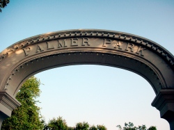
SW: Palmer Park, which is rather nice.

NW: A large Walgreens is now under construction where an abandoned, rotting retail development sat for at least the past 10 years.

NE: An abandoned gas station (4 years now?).

SE: A suburban-style bank branch, still unrestored since Katrina. Plans to build a bigger suburban-style branch, minus the oak trees, is in the works.

And in the very center of the intersection, there is a concrete island with some overgrown bushes and this–perhaps a Gateway to Hell?

End of the line

End of the line

Originally uploaded by nola-shiva.

When the tiny Buddha at the foot of Carrollton turns his gaze up the avenue this is what he sees. A mess. Port-a-pissers, trash cans, a welter of overhead wires and traffic. This is what tourists–our economic life blood, for good or ill–also see. Been this way for a long time, although the rubbermaid toilets are relatively new, having replaced underground facilities that had been closed even before Katrina. (I don’t even want to imagine what that scene must be like now.)
Whenever I used to see bewildered tourists and our local rail-riders waiting around here for the next car to roll I wondered why RTA couldn’t come up with a little money and imagination to at least build a shelter here. It ought to be a DESTINATION–that is, something worth the trip.

But there is Palmer Park, right there at the end of the line. Palmer Park

No shelter, but a nice entry monument, some benches, live oaks and a war monument. About one city block in area. Well maintained, lately. And once a month it is the site for the MidCity Art Market.

Green development measures up, according to some studies

Building and developing real estate using green design principles, practices and materials is attractive in a feel-good way. But where are the hard facts? Is it measurably better in commonly understood ways? That is, financially?

Two recent reports seem to show it is. One study found that “low impact development” (LID) was cheaper to build, cheaper to maintain, and more profitable than the standard slash and burn approach. “However, existing zoning laws, stormwater management regulations and other barriers inhibit LID”, the report went on to say. See Crunching the Numbers on Low Impact Development in Minnesota

Green affordable housing seems to cost a little more to build–but not much–and the benefits to tenants, in terms of utility bills, and even health, might be substantial.

So is anyone in the local (re)development stream–affordable or market rate–paying heed to LID and green building? I think that progress is being made in this direction. Check out Global Green and what they are doing locally. But here, like most everywhere else, old habits persist.

Carrollton transect

Sometime last year, I believe, NPR had a series of stories following a biologist who was trekking along a straight line through central Africa. It provided a fascinating survey of the changing scene across this part of the continent.

It might be interesting to chart the transect of the city defined by Carrollton Avenue, which runs from the river to the lake (with a name change). It passes through several distinct zones, each with its own history and character. There are changes in ecology/environment, economy, sociology, ethnicity, etc.

For example, the section between St. Charles Ave and Claiborne might be called the tree zone. It is mostly residential and heavily shaded by grand old live oaks. The streetcar is also a major feature. The sidewalk level temperature in summer is lower here, I’d bet, than in the next two or three zones towards the lake. The houses right along the Avenue are quite nice, mostly, and the residents among the city’s more affluent. (Not as affluent as along St. Charles or a few other Avenues, but upper middle class. But, this being New Orleans, go a block or two off Carrollton and the socioeconomic scne changes dramatically.)

The next section, between Claiborne and Earhart, is a transition zone from tree/residential to commercial. Perhaps a little less affluent. Different vegetation, ecosystem.

Then from Earhart to about Tulane Avenue it becomes a commercial zone, rather down at the heels, especially since Katrina, as this area flooded heavily. Potential to become a better commercial zone.

There are several more distinct zones from Tulane to City Park Avenue, where Carrollton Avenue ends, although the road continues under the name Wisner Avenue.